|
Communities
There are approximately 2,400 participants in the Gwich'in Land
Claim, with 60% of the people living in the four communities of
the Gwich'in Settlement Area. Aklavik (population 727) is a mixed
community of Gwich'in and Inuvialuit, while Inuvik (population 3,296)
has a mixed population of Gwich'in, Inuvialuit and non-aboriginals.
The two predominantly Gwich'in communities are Fort McPherson (population
878) and Tsiigehtchic (population 162).
Gwich'in live in an area that includes north-east Alaska, the northern
Yukon and the north-western part of the Northwest Territories. Two
of the original Gwich'in groups are found in the Gwich'in Settlement
Area. The Gwichya Gwich'in live primarily in Tsiigehtchic, and the
Teetl'it Gwich'in live primarily in Fort McPherson. Gwich'in in
Aklavik and Inuvik have formed their own bands in the past 20 years:
the Ehdiitat Gwich'in in Aklavik and the Nihtat Gwich'in in Inuvik.
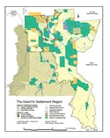
The Gwich'in Settlement Region
The Gwich'in Land Claim was settled in 1992 for the Gwich'in Settlement
Region. The Gwich'in Settlement Region is made up of the Gwich'in
Settlement Area, the Primary Use Area and the Secondary Use Area
(see map). The Gwich'in Settlement Area is entirely in the Northwest
Territories and is approximately 56,935 km2. The Planning Board
is responsible for land use planning in the Gwich'in Settlement
Area.
Both the Primary and Secondary Use Areas are in the Yukon Territory.
The Primary Use Area (21,988 km2) encompasses much of
the watershed of the Peel River. It is an overlap area between the
Nacho N'yak Dun of Mayo and the Teetl'it Gwich'in of Fort McPherson.
The Secondary Use Area (11,456 km2) is a traditional
use area in the Richardson Mountains. The three main groups that
use the area are the Vuntut Gwitchin of Old Crow, the Teetl'it Gwich'in
of Fort McPherson and the Ehdiitat Gwich'in of Aklavik. The responsibility
for land use planning in the Primary and Secondary Use Areas falls
to the Yukon Land Use Planning Council. The Yukon Transboundary
Agreement states that the Yukon Land Use Planning Council will consult
with the Planning Board on any land use planning initiatives in
the Primary and Secondary Use Areas. A planning commission for the
Peel River watershed, which includes most of the Primary Use Area,
is expected to be established in 2004.
The Gwich'in Settlement Area is bordered by the Inuvialuit Settlement
Region to the north, the Sahtu Settlement Area to the southeast
and the Yukon Territory to the west. In the Inuvialuit Settlement
Region, community conservation plans have been developed in place
of Land Use Plans. Gwich'in settlement lands in the Inuvialuit Settlement
Region are addressed in the conservation plans as the Planning Board
has no jurisdiction in the Inuvialuit Settlement Region. In the
Sahtu Settlement Area, the Sahtu Land Use Planning Board have published
a preliminary draft Land Use Plan.
|