 |
|
Nành'
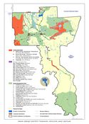
Geenjit Gwitr'it T'igwaa'in (Working for the Land), the Gwich'in
Land Use Plan (9,692 KB) is the plan for the Gwich'in Settlement
Area under the Mackenzie Valley Resource Management Act. It covers
all lands within the Settlement Area that are outside of municipal
boundaries, an area just under 57,000 km2. In the Land
Use Plan's six year development stage, the Planning Board consulted
extensively with Gwich'in communities and organizations, territorial
and federal government departments, industry groups and environmental
non-government organizations. The Land Use Plan is based on existing
traditional and scientific knowledge about the region. After plan approval (August 2003), all licenses, permits or other authorizations relating to the use of land, water or the deposit of waste in the Settlement Area must conform to the Land Use Plan. There is some flexibility with respect to conformance because the Planning Board will consider making exceptions and amendments. What are the basics of the Plan? There are many resources the land supplies and many ways land, water and resources can be used. The Planning Board appreciates that using land resources should benefit the people of the Gwich'in Settlement Area and Canada as a whole. For this reason, the Planning Board encourages multiple uses or many uses of the land. Land resources should be used for the maximum gain of the people of the area. All land uses are important and meet different human needs. There are a number of different potential land uses for the Gwich'in Settlement Area such as traditional activities (which may include a spiritual aspect), transportation, waste disposal, military activities, mining, oil and gas activities, sand and gravel pits, power developments, timber harvest, commercial fisheries, and tourism. Often land uses take place without any concerns being raised. Sometimes different land uses compete for the same resources causing land use conflicts. Other times land uses impact on people living and using the area, or the environment that people depend on. One way to avoid land use conflicts and negative impacts on people or the environment is to identify what land uses should and should not take place in areas before they are proposed. For this plan, this is done using a Land Zoning System. The Land Zoning System describes what is allowed or not allowed in specific areas. This Zoning System has three zones: Gwich'in General Use Zones, Gwich'in Special Management Zones, and Gwich'in Conservation Zones (which includes the sub category of Heritage Conservation Zones). This system promotes multiple or many uses of land, water and resources in certain areas and controls activities in critical and sensitive environmental and heritage areas. The zoning strives to achieve a balance between conservation of the land and the use of land, water and resources to meet human needs. In more detail the zones are:
Please consult the Plan for more detail about the values of these zones and the planning process. Nành' Geenjit Gwitr'it T'igwaa'in required the approval of the Gwich'in Tribal Council, the Minister of the Department of Resources, Wildlife and Economic Development and the Minister of the Department of Indian Affairs and Northern Development. In September 1999, the Gwich'in Tribal Council approved the Plan. The Government of the Northwest Territories then approved it, with minor changes, in November of that same year. During their final review for approval, the federal government raised some very fundamental concerns. In the seventeen proposed Gwich'in Conservation Zones, the Plan does not allow for development requiring licences, permits, or other authorizations. The main issue was the free access provisions in the Canada Mining Regulations (CMRs) conflicted with these restrictions. Bob Simpson, the Board's chair, and the Gwich'in Tribal Council met with Minister Nault in November 2001 and agreed on the steps to finally get the Plan approved. The agreement was that all of the Conservation Zones (including the Heritage Conservation Zone subset) be withdrawn from any subsurface activity until January 2008. In this time, the CMRs will be changed to be consistent with the land use plan. Minister Nault also agreed to fund mineral and energy assessments in the Conservation Zones so that the Board may do more detailed planning in the future. Any changes that were made to the plan during the Federal review process were taken to the communities, the Gwich'in Tribal Council, and the Territorial Government for approval. Once the wording was agreed to and the interim land withdrawal in place, the plan received its final approval from Minister Nault. The dates of the land use plan final approval are:
As of August 7, 2003, the plan is considered to be in effect. Any amendments to the land use plan will require approval of the same three signatories. The History of the Gwich'in Land Use Plan The Gwich'in are as much a part of the land as the land is a part of their culture, values, and traditions. In the past they were stewards of the land on which they lived, knowing that their health as people and a society was intricately tied to the health of the land. In response to the Berger enquiry of the mid 1970's, the government of Canada made a commitment to recognise this relationship by establishing new programmes and institutions to give the Gwich'in people a role as stewards once again. One of the actions taken has been the creation of a formal land use planning process. Many people from all communities in the Gwich'in Settlement Area have worked diligently on land use planning in this formal process with the government since the 1980s. Throughout these years people have continued to put their time and energy into land use planning because of their commitment to taking care of the land and their childrens' future. The Gwich'in helped to set the framework for the 1983 Basis of Agreement on Northern Land Use Planning. The first attempt to develop a Land Use Plan was through the Mackenzie Delta Beaufort Sea Land Use Planning process which was appointed in 1987 and included Gwich'in representatives. The Mackenzie Delta Beaufort Sea Land Use Plan produced in 1991 was not approved or implemented by government. After the signing of the Gwich'in Land Claim in 1992, the Gwich'in Interim Land Use Planning Board was given the task to begin land use planning again. However, it was not until the Mackenzie Valley Resource Management Act was passed in 1998 that there was the legal authority to produce a Gwich'in Land Use Plan. After approximately 20 years of work on the part of many people, the Gwich'in Land Use Planning Board (Planning Board) is proud to present Nanh' geenjit gwitr'it t'igwaa'in/Working for the Land - Gwich'in Land Use Plan.
|
Copyright © 2025 Gwich'in Land Use Planning Board |